Showing 105 items matching sewerage plans
-
 Federation University Historical Collection
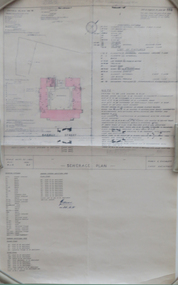
Plan - Plans, Barkly Street Girls' School Sewerage Plans, c1952
... Barkly Street Girls' School Sewerage Plans...sewerage plans...Two hand coloured sewerage plans .1) Barkly Street .2... Plan Barkly Street Girls' School Sewerage Plans Two hand ...Two hand coloured sewerage plans .1) Barkly Street .2) as aboveplans, sewerage plans, percy everett, barkly street, ballarat east, girls' school -
Ballarat Heritage Services
Plan, 105 Lyons St Sewerage Plans
... 105 Lyons St Sewerage Plans...Sewerage plans... Office goldfields Plan 105 Lyons St Sewerage Plans Sewerage plans ...sewerage plans, 105 lyons street south, combined drain, combined sewer -
 Federation University Historical Collection
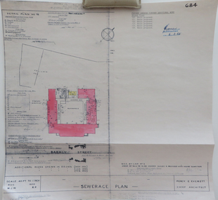
Plan, Sewerage Plan, 1950
... Sewerage Plan...sewerage plans...Hand coloured sewerage plan: Barkly St ... Plan Sewerage Plan Hand coloured sewerage plan: Barkly St plans ...Hand coloured sewerage plan: Barkly St plans, sewerage plans, percy everett -
 Federation University Historical Collection
Plan, Plan (dyeline): Ballarat Girls' School Sewerage Plan, 1950
... Plan (dyeline): Ballarat Girls' School Sewerage Plan...sewerage plans...Plan (dyeline) for Ballarat Girls' School sewerage plan ... Plan Plan (dyeline): Ballarat Girls' School Sewerage Plan Plan ...Plan (dyeline) for Ballarat Girls' School sewerage plan percy everett, ballarat girls' school, sewerage plans -
 Federation University Historical Collection
Plan, Ballarat School of Mines Plan of Drainage, 1980?
... Photocopied Sewerage Plan for Albert Street Scale 1: 480... Sewerage Plan for Albert Street Scale 1: 480 ballarat school ...Photocopied Sewerage Plan for Albert Street Scale 1: 480ballarat school of mines, ballarat sewerage authority, museum, welding shop, machine shop, ballarat junior technical school, plumbing -
Whitehorse Historical Society Inc.
Map, Anjaya Court, Blackburn, ca1970
... Court, Lots 21-24. One copy with proposed sewerage plan.... copy with proposed sewerage plan. Anjaya Court Blackburn Land ...[Plan of] Anjaya Court, Blackburn, Lots 6 - 20and of Leons Court, Lots 21-24. One copy with proposed sewerage plan.anjaya court, blackburn, land subdivision, sewerage and sanitation -
Glenelg Shire Council Cultural Collection
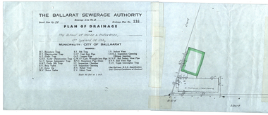
Plan - Plan - Portland Sewerage Association, n.d
... Plan - Portland Sewerage Association...Portland Sewerage Authority Plan of Drainage for Mrs M... Cliff Street Portland great-ocean-road Plan - Portland Sewerage ...Portland Sewerage Authority Plan of Drainage for Mrs M Campbellcampbell family records -
 Ringwood and District Historical Society
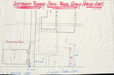
Plan - Plans, Southwood Primary School, Ringwood, Collection of plans for water supply, sewerage and drainage
... Southwood Primary School, Ringwood, Collection of plans for...Southwood P.S. Water Supply, Sewerage & Drainage Plans... School, Ringwood, Collection of plans for water supply, sewerage ...folder of paper plansSouthwood P.S. Water Supply, Sewerage & Drainage Plans. Permanent File. To be archived at P.R.O. when no longer required. -
 Ringwood and District Historical Society
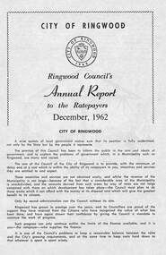
Pamphlet, F.P. Dwerryhouse, Town Clerk and Treasurer, Ringwood Council's Annual Report To The Ratepayers (December 1962), 1962
... Valuations, Private Street Construction, Other New Works, Sewerage... Valuations, Private Street Construction, Other New Works, Sewerage ...City of Ringwood community information report issued December 1962, including financial summary and sections covering Valuations, Private Street Construction, Other New Works, Sewerage, Planning Scheme, Annual Special Clearance of Refuse, Elderly Citizens' Village, Elderly Citizens' Clubrooms, Fire Hazards, and list of Council Representatives.Vale - ex-Cr. A.T. Miles, Mr. A.F.B. Long, Mr. F.R. Lucas.rinx -
 Whitehorse Historical Society Inc.
Document, Sewerage area, 22/09/1933 12:00:00 AM
... Plan of sewerage area no. 974, Shire of Blackburn... Mitcham melbourne Document Document Sewerage area Plan of sewerage ...Plan of sewerage area no. 974, Shire of Blackburn and Mitcham. Scale 400' to an inch. 22 September 1933.sewerage and sanitation, shire of blackburn and mitcham, whitehorse road, blackburn, vine street, parkside street, alfred street, main street, the avenue, gordon crescent -
 Whitehorse Historical Society Inc.
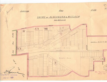
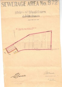
Document, Sewerage area, 13/07/1933 12:00:00 AM
... Plan of sewerage area no. 972, Shire of Blackburn... Mitcham melbourne Document Document Sewerage area Plan of sewerage ...Plan of sewerage area no. 972, Shire of Blackburn and Mitcham, scale 400' to an inch. 13 July 1933. Note that the area including Stuart Street on the map is now the Thiele Court area.sewerage and sanitation, shire of blackburn and mitcham, whitehorse road, blackburn, railway road, vine street, lithgow avenue, downing street, frankston street, stuart street, thiele court -
Port Melbourne Historical & Preservation Society
Document - File, Port Melbourne Yacht Club, 1970s - 1990s
... Port Melbourne Yacht Club .01 -Sewerage connection 1975... Document Port Melbourne Yacht Club .01 -Sewerage connection 1975 ...Port Melbourne Yacht Club .01 -Sewerage connection 1975 - including plans .02 - PMYC expansion report. Original 1976 including plans and photos .03 - Rebuilding of clubhouse 1992. Including plans sport - yachting, built environment - recreational facilities -
 Ringwood and District Historical Society
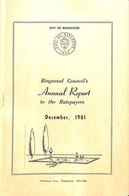
Pamphlet, F.P. Dwerryhouse, Town Clerk and Treasurer, Ringwood Council's Annual Report To The Ratepayers (December 1961), 1961
... Construction, New Works, Sewerage, Street Lighting, Planning Scheme... Construction, New Works, Sewerage, Street Lighting, Planning Scheme ...City of Ringwood community information report issued December 1961, including financial summary and sections covering Re-Valuation, Sanitary Charge, Garbage Removal Charge, Private Street Construction, New Works, Sewerage, Street Lighting, Planning Scheme, Fire Hazards, Fly Control, Dog Nuisance, and list of Council Representatives.rinx -
 Federation University Historical Collection
Plans, Plans of the Ballarat School of Mines, Lydiard Street South, Ballarat, 1953
... . James. .5) Ballarat Sewerage Authority Plan of Drainage.... James. .5) Ballarat Sewerage Authority Plan of Drainage ....3) Ballarat School of Mines plan for water supply installation to prefabricated classrooms associated with the Ballarat Girls' Techncial School, April 1953 .4) Ballarat School of Mines plans for three prefabricated classrooms to be used as the Ballarat Girls' Techncial School, Hickman Street, Ballarat by Percy E. Everett, 16 December 1952. Earthworks undertaken by T.G. James. .5) Ballarat Sewerage Authority Plan of Drainage Prefabricated Class Rooms Ballarat School of Mines by Chief Architect Percy E. Everett, 13 April 1953. The plan shows basket ball court and shelter, classrooms, contours, excavations and girls toilet associated with the Ballarat Girls' Techncial School, Hickman Street, Ballarat. ballarat junior girls' technical school, ballarat girls' technical school, ballarat school of mines, hickman street, white flat, t.g. james -
 Kew Historical Society Inc
Plan - Subdivision Plan, Tregarron Estate, Kew, c.1929
... of the drainage and sewerage easements. This plan is interesting... and the placement of the drainage and sewerage easements. This plan ...Pru Sanderson, in her groundbreaking ‘City of Kew Urban Conservation Study : Volume 2 - Development History’ (1988), summarised the periods of urban development and subdivisions of land in Kew. The periods that she identified included 1845-1880, 1880-1893, 1893-1921, 1921-1933, 1933-1943, and Post-War Development. These periods were selected as they represented periods of rapid growth or decline in urban development. An obvious starting point for Sanderson’s groupings involved population growth and the associated economic cycles. These cycles also highlighted urban expansion onto land that was predominantly rural, although in other cases it represented the decline and breakup of large estates. A number of the plans in the Kew Historical Society’s collection can also be found in other collections, such as those of the State Library of Victoria and the Boroondara Library Service. A number are however unique to the collection.Subdivision plans are historically important documents used as evidence of the growth of suburbs in Australia. They frequently provide information about when the land was sold on which a built structure was subsequently constructed as well as evidence relating to surveyors and real estate and financial agents. The numerous subdivision plans in the Kew Historical Society's collection represent working documents, ranging from the initial sketches made in planning a subdivision to printed plans on which auctioneers or agents listed the prices for which individual lots were sold. In a number of cases, the reverse of a subdivision plan in the collection includes a photograph of a house that was also for sale by the agent. These photographs provide significant heritage information relating house design and decoration, fencing and household gardens.In January 1929, the Kew City Council called for tenders to construct Tregarron Avenue. The subdivision of the Tregarron Estate in Kew was for 11 lots bordering Tregarron Avenue and its entrance from Burke Road. The plan includes annotations that indicate the measurement of each block and the placement of the drainage and sewerage easements. This plan is interesting for a number of factors. The house blocks today have different street numbers, some blocks were to be further subdivided, and at the time of the subdivision, alterations were still being made to the extent of lots offered; lots 2 and 3 on the plan were subdivided and reoriented.subdivision plans - kew, tregarron estate, tregarron avenue -- kew (vic.), burke road -- kew (vic.) -
 Greensborough Historical Society
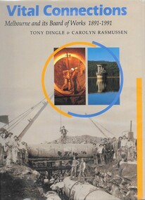
Book, Vital connections: Melbourne and its Board of Works 1891-1991, by Tony Dingle & Carolyn Rasmussen, 1991_
Centenary history of the Melbourne and Metropolitan Board of Works, the organisation responsible for Melbourne's water supply, sewerage and industrial waste disposal, town planning, rivers & creeks, metropolitan parks and building of freeways until its closure in 1992.432 p. hardback, black & white photographsmmbw, melbourne and metropolitan board of works -
 Ringwood and District Historical Society
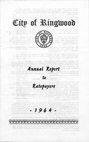
Pamphlet, F.P. Dwerryhouse, Town Clerk and Treasurer, City of Ringwood Annual Report To The Ratepayers - 1964, 1964
City of Ringwood community information report for 1964, including sections covering Valuations-Rates, Sanitary Service - Sewerage, Private Street Construction, Loughnan Hill Road Scheme, Other New Works, Planning Scheme, Fire Hazards, Fly Control, Dogs, Annual Special Clearance of Refuse, Garbage Removal, Immunisation, Street Lighting, House Numbers, Home Help, Scholarships, Rubbish Dumping, Vandalism, and list of Council Representatives.rinx -
 Ringwood and District Historical Society
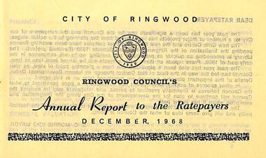
Pamphlet, Ringwood Council's Annual Report To The Ratepayers - December 1968, 1968
City of Ringwood community information annual report for 1968, including sections covering Finance, General Valuation and Rater Payments, Property Ownership Changes, Refuse, Sanitary Serviced, Sewerage Connections to MMBW, Dandenong Valley Authority, Residential Flat Control Planning Scheme, Immunisation, Home Help, Elderly Citizens' Clubrooms, Library, Civic Centre, Golf Course, Sale of Council Land, Swimming Centre, Holiday Play Centre, Civic Week, Lake Reserve Improvements, Rubbish Dumping, Street Trees, Vandalism, White Ants, Street Construction, Fire Hazards, Dog Nuisance, House Numbering, Citizens' Advisory Service, Infant Welfare Centres, and a list of departing and current Council Representatives. Also includes general reminders regarding rat extermination, free firewood for age pensioners, overhanging vegetation, and spouses voting rights.Obituary - Mr. F.P. Dwerryhouse, Town Clerk for the past 9-1/2 years passed away on 6th December after a short illness.rinx -
 Warrnambool and District Historical Society Inc.
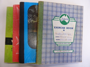
Booklet, Allansford Progress Association, Second half of 20th century
These four exercise books give documentation on the activities of the Allansford Progress Association (1966 to 1988). Allansford is a settlement about 9 kilometres from Warrnambool and most of the town area is now within the boundaries of the Warrnambool City Council. The association was re-formed in November 1966 after the demise of an earlier group. The members of the group campaigned in areas of local concern – T. V. reception, drainage and sewerage, postal services, sports facilities including the development of the Speedway, housing development, road proposals, waste management and disaster plans. These books are of interest in that they provide an overview of the history of a local organization. They will be useful for research. These are four exercise books - three Minutes books, and one Accounts book, from the Allansford Progress Association (1966-1988). The exercise books have coloured covers, (blue and white checkered, green, red and blue). Two are bound with tape and two are stapled. There are some loose sheets in all of the books. All the entries are handwritten. On front covers: ‘Allansford Progress Association’allansford progress association, history of allansford, history of warrnambool -
University of Melbourne, Burnley Campus Archives
Plan - Photocopy, County, c.1930
Given to Archives by Emma Ferguson and Jo van Berkel who used it in preparation of their 1994 thesis on the history of the Burnley Gardens. Photocopy of a plan depicting Burnley College as it was in the 1930's. It shows the Pavilion and surrounding gardens, coops and yards, various small outbuildings. Shows the contours of the land in the northern section of the property bordering Swan St. Some additions and comments have been added to original document, mainly to do with sewerage and water supplyburnley college, pavilion, emma ferguson, jo van berkel -
University of Melbourne, Burnley Campus Archives
Plan, 25 Wakanui Street, 1996
Plans for a garden at 25 Wakanui Street by Holmes Design. (1) Point Location Data showing plumbing fixtures. (2) Tracing paper and paper copies Dwg No 13 Site Inventory & Analysis 4/6/96. Scale 1:100. (3) Coloured tracing paper and paper copies, Dwg No 15 Preliminary Plan 6/6/96. Scale 1:100. (4) Tracing paper and paper copies Dwg No 16 Section View Backyard 6/6/96. Scale 1:50. (5) Photocopy of Certificate of Title and Sewerage.wakanui street, holmes design -
![Vital Connections: Melbourne and its Board of Works 1891-1991 / [by] A.E. Dingle](https://victoriancollections.net.au/media/collectors/550653872162f11fb04854aa/items/5ece65f9f36c2704c4f2b67b/item-media/5ece66eef36c2704c4f2b783/item-fit-380x285.jpg) Kew Historical Society Inc
Kew Historical Society IncBook, A.E. Dingle, Vital Connections: Melbourne and its Board of Works 1891-1991, 1991
Ringwood, Vic. : McPhee Gribble, 1991 432 p. : ill. (some col.), maps, ports. ; 25 cm. non-fictionmelbourne and metropolitan board of works -- history., melbourne (vic.) -- public works -- history., cartography -
University of Melbourne, Burnley Campus Archives
Plan (Item) - Coloured plan, laminated, Sewerage & Water Plan
... Sewerage & Water Plan... Boulevard Richmond melbourne Coloured plan, laminated Plan Sewerage ... -
 Kew Historical Society Inc
Plan, Melbourne & Metropolitan Board of Works : Borough of Kew : Detail Plan No.1291, 1905
The Melbourne and Metropolitan Board of Works (MMBW) plans were produced from the 1890s to the 1950s. They were crucial to the design and development of Melbourne's sewerage and drainage system. The plans, at a scale of 40 feet to 1 inch (1:480), provide a detailed historical record of Melbourne streetscapes and environmental features. Each plan covers one or two street blocks (roughly six streets), showing details of buildings, including garden layouts and ownership boundaries, and features such as laneways, drains, bridges, parks, municipal boundaries and other prominent landmarks as they existed at the time each plan was produced. (Source: State Library of Victoria). This plan forms part of a large group of MMBW plans and maps that was donated to the Society by the Mr Poulter, City Engineer of the City of Kew in 1989. Within this collection, thirty-five hand-coloured plans, backed with linen, are of statewide significance as they include annotations that provide details of construction materials used in buildings in the first decade of the 20th century as well as additional information about land ownership and usage. The copies in the Public Record Office Victoria and the State Library of Victoria are monochrome versions which do not denote building materials so that the maps in this collection are invaluable and unique tools for researchers and heritage consultants. A number of the plans are not held in the collection of the State Library of Victoria so they have the additional attribute of rarity.Original survey plan, issued by the MMBW to a contractor with responsibility for constructing sewers in the area identified on the plan within the Borough of Kew. The plan was at some stage hand-coloured, possibly by the contractor, but more likely by officers working in the Engineering Department of the Borough and later Town, then City of Kew. The hand-coloured sections of buildings on the plan were used to denote masonry or brick constructions (pink), weatherboard constructions (yellow), and public buildings (grey). A detail plan of part of Studley Park bordered by the major streets of Hodgson Street, Stevenson Street and Studley Park Road. Included on the plan are a number of significant Studley Park mansions in existence at the beginning of the 20th century. The unnamed street shown in the middle of the plan is McEvoy Street. The most important house still extant is Campion House, formerly named Dalsraith [Dalswraith] and Glendalough, owned since the 1940s by the Society of Jesus. Campion House can be seen on the corner of Hodgson and Studley Park Road. Its stables at the rear of the block have now been incorporated into a contemporary residence. An interesting feature of the plan is the 1910 annotation by Ed Seitz, professional designing engineer. Is Seitz the contractor who modified the MMBW original?melbourne and metropolitan board of works, detail plans, mmbw 1291, cartography -
 Kew Historical Society Inc
Plan, Melbourne and Metropolitan Board of Works, Melbourne & Metropolitan Board of Works : Borough of Kew : Detail Plan No.1294 & 1295, 1904
The Melbourne and Metropolitan Board of Works (MMBW) plans were produced from the 1890s to the 1950s. They were crucial to the design and development of Melbourne's sewerage and drainage system. The plans, at a scale of 40 feet to 1 inch (1:480), provide a detailed historical record of Melbourne streetscapes and environmental features. Each plan covers one or two street blocks (roughly six streets), showing details of buildings, including garden layouts and ownership boundaries, and features such as laneways, drains, bridges, parks, municipal boundaries and other prominent landmarks as they existed at the time each plan was produced. (Source: State Library of Victoria). This plan forms part of a large group of MMBW plans and maps that was donated to the Society by the Mr Poulter, City Engineer of the City of Kew in 1989. Within this collection, thirty-five hand-coloured plans, backed with linen, are of statewide significance as they include annotations that provide details of construction materials used in buildings in the first decade of the 20th century as well as additional information about land ownership and usage. The copies in the Public Record Office Victoria and the State Library of Victoria are monochrome versions which do not denote building materials so that the maps in this collection are invaluable and unique tools for researchers and heritage consultants. A number of the plans are not held in the collection of the State Library of Victoria so they have the additional attribute of rarity.Original survey plan, issued by the MMBW to a contractor with responsibility for constructing sewers in the area identified on the plan within the Borough of Kew. The plan was at some stage hand-coloured, possibly by the contractor, but more likely by officers working in the Engineering Department of the Borough and later Town, then City of Kew. The hand-coloured sections of buildings on the plan were used to denote masonry or brick constructions (pink), weatherboard constructions (yellow), and public buildings (grey).The streets and built structures in MMBW Detail Plan 1294 & 1295 were surveyed in 1903 and released to contractors in 1904. This plan is one of two in the collection where the lithographers amalgamated two separate plans. Both plans include sections of Studley Park. Dominating the south and west corners of Kew Junction are the Clifton and Kew Hotels. The Kew Hotel, owned by Patrick O’Shaughnessy was one of the oldest in Kew. MMBW plans were amended over time to take account of new subdivisions such as that which created Merrion Place. Of the four mansions shown in Studley Park Road, three remain – ‘Field Place’, the home of Frances Henty, ‘Leaghur’ and ‘Darley’. ‘Byram’ (later ‘Goathland’, then ‘Tara Hall’) was an architectural marvel. Designed in 1888 by E.G. Kilburn for the paper magnate George Ramsden, it was demolished in 1960. While an earlier sale of the southern section of Byram had created Tara Avenue in 1927, the demolition of the house in 1960 enabled the extension of Tara Avenue northward.melbourne and metropolitan board of works, detail plans, mmbw 1294, mmbw 1295, cartography -
 Kew Historical Society Inc
Plan, Melbourne & Metropolitan Board of Works : Borough of Kew : Detail Plan No.1296, 1904
The Melbourne and Metropolitan Board of Works (MMBW) plans were produced from the 1890s to the 1950s. They were crucial to the design and development of Melbourne's sewerage and drainage system. The plans, at a scale of 40 feet to 1 inch (1:480), provide a detailed historical record of Melbourne streetscapes and environmental features. Each plan covers one or two street blocks (roughly six streets), showing details of buildings, including garden layouts and ownership boundaries, and features such as laneways, drains, bridges, parks, municipal boundaries and other prominent landmarks as they existed at the time each plan was produced. (Source: State Library of Victoria)This plan forms part of a large group of MMBW plans and maps that was donated to the Society by the Mr Poulter, City Engineer of the City of Kew in 1989. Within this collection, thirty-five hand-coloured plans, backed with linen, are of statewide significance as they include annotations that provide details of construction materials used in buildings in the first decade of the 20th century as well as additional information about land ownership and usage. The copies in the Public Record Office Victoria and the State Library of Victoria are monochrome versions which do not denote building materials so that the maps in this collection are invaluable and unique tools for researchers and heritage consultants. A number of the plans are not held in the collection of the State Library of Victoria so they have the additional attribute of rarity.Original survey plan, issued by the MMBW to a contractor with responsibility for constructing sewers in the area identified on the plan within the Borough of Kew. The plan was at some stage hand-coloured, possibly by the contractor, but more likely by officers working in the Engineering Department of the Borough and later Town, then City of Kew. The hand-coloured sections of buildings on the plan were used to denote masonry or brick constructions (pink), weatherboard constructions (yellow), and public buildings (grey). This area was once known as O’Shaughnessy’s Paddock. O’Shaughnessy was the licensee of the Kew Hotel. The ‘Paddock’ or farm was for many years the closest farm to Melbourne. By 1903, when this plan was surveyed and lithographed, little of the farm remained. The area is dominated by a ‘clay hole’, on the site of the current Foley Reserve. It was used by Smart’s Brickyard from the 1880s until 1911, when the Council purchased it for a rubbish dump. It is notable as the site is one of the few industrial operations to have existed in Kew. By 1903, urban development was characterised by larger houses fronting Barkers Road and brick and weatherboard villas in Foley Street. Nearer the pit, weatherboard houses predominated. Foley Street bisected the triangular block and continued right to Denmark Street. At this stage, a house impeded the through road, only allowing access via a right of way to High Street.melbourne and metropolitan board of works, detail plans, mmbw 1296, cartography -
 Kew Historical Society Inc
Plan, Melbourne & Metropolitan Board of Works : Borough of Kew : Detail Plan No.1297, 1904
The Melbourne and Metropolitan Board of Works (MMBW) plans were produced from the 1890s to the 1950s. They were crucial to the design and development of Melbourne's sewerage and drainage system. The plans, at a scale of 40 feet to 1 inch (1:480), provide a detailed historical record of Melbourne streetscapes and environmental features. Each plan covers one or two street blocks (roughly six streets), showing details of buildings, including garden layouts and ownership boundaries, and features such as laneways, drains, bridges, parks, municipal boundaries and other prominent landmarks as they existed at the time each plan was produced. (Source: State Library of Victoria)This plan forms part of a large group of MMBW plans and maps that was donated to the Society by the Mr Poulter, City Engineer of the City of Kew in 1989. Within this collection, thirty-five hand-coloured plans, backed with linen, are of statewide significance as they include annotations that provide details of construction materials used in buildings in the first decade of the 20th century as well as additional information about land ownership and usage. The copies in the Public Record Office Victoria and the State Library of Victoria are monochrome versions which do not denote building materials so that the maps in this collection are invaluable and unique tools for researchers and heritage consultants. A number of the plans are not held in the collection of the State Library of Victoria so they have the additional attribute of rarity.Original survey plan, issued by the MMBW to a sewage contractor with responsibility for constructing sewers in the area identified on the plan within the Borough of Kew. The plan was at some stage hand-coloured, possibly by the contractor, but more likely by officers working in the Engineering Department of the Borough and later Town, then City of Kew. The hand-coloured sections of buildings on the plan were used to denote masonry or brick constructions (pink), weatherboard constructions (yellow), and public buildings (grey). This plan of Kew encompasses the area bounded by Barkers Road, High Street and Stevenson Street. Because of the angle created by High Street, a number of houses on the northern side of High Street are shown. The area is dominated by one of the great original landholdings in Kew, described here as the ‘Findon Paddock’. ‘Findon’, the house from which the name of the paddock was taken fronts Stevenson Street and was clearly a rambling structure. The best-known occupant of Findon was Henry ‘Money Miller’ who bought the house in 1871. Miller was a member of Victoria’s first parliament and assisted in the framing of its constitution. Findon was to be subdivided as early as 1912, when the Findon Subdivision was advertised to be sold by auction. In the plan of the subdivision, the original house is not shown, so, presumably it had previously been demolished. Fincham & Son moved the organ, built by Henry Willis, which was installed in the house, first to ‘Whernside’ in Toorak, and later to the Box Hill Methodist Church.melbourne and metropolitan board of works, detail plans, mmbw 1297, cartography, kew (vic.) — municipal collection -
 Kew Historical Society Inc
Plan, Melbourne & Metropolitan Board of Works : Borough of Kew : Detail Plan No.1301, 1910
The Melbourne and Metropolitan Board of Works (MMBW) plans were produced from the 1890s to the 1950s. They were crucial to the design and development of Melbourne's sewerage and drainage system. The plans, at a scale of 40 feet to 1 inch (1:480), provide a detailed historical record of Melbourne streetscapes and environmental features. Each plan covers one or two street blocks (roughly six streets), showing details of buildings, including garden layouts and ownership boundaries, and features such as laneways, drains, bridges, parks, municipal boundaries and other prominent landmarks as they existed at the time each plan was produced. (Source: State Library of Victoria)This plan forms part of a large group of MMBW plans and maps that was donated to the Society by the Mr Poulter, City Engineer of the City of Kew in 1989. Within this collection, thirty-five hand-coloured plans, backed with linen, are of statewide significance as they include annotations that provide details of construction materials used in buildings in the first decade of the 20th century as well as additional information about land ownership and usage. The copies in the Public Record Office Victoria and the State Library of Victoria are monochrome versions which do not denote building materials so that the maps in this collection are invaluable and unique tools for researchers and heritage consultants. A number of the plans are not held in the collection of the State Library of Victoria so they have the additional attribute of rarity.Original survey plan, issued by the MMBW to a contractor with responsibility for constructing sewers in the area identified on the plan within the Borough of Kew. The plan was at some stage hand-coloured, possibly by the contractor, but more likely by officers working in the Engineering Department of the Borough and later Town, then City of Kew. The hand-coloured sections of buildings on the plan were used to denote masonry or brick constructions (pink), weatherboard constructions (yellow), and public buildings (grey). Throughout its history, the land in what is known today as Studley Ward of the City of Boroondara has been subject to continuing subdivision. This is evident in Plan 1301, where later hands have modified the original map to include streets created subsequent to the printing of the plan in 1904. Other annotations such as the ‘Reserved for Road Purposes’ beside the Yarra never eventuated. The plan continued to be modified to at least 1953, when a later hand noted that a particular site was ‘Property site P. McIntyre house’ in Swinton Avenue. Two significant houses in the area are outlined on the plan: ‘Swinton’ on the corner of the streets then named Effey and Maud Streets (now Swinton Avenue) and ‘Fairhaven’ [unnamed] in Stevenson Street. The gardens of the two David Syme owned mansions of ‘Blythswood’ and ‘Rockingham’, stretching down to the River Yarra, are also represented.melbourne and metropolitan board of works, detail plans, mmbw 1301, cartography -
 Kew Historical Society Inc
Plan, Melbourne & Metropolitan Board of Works : Borough of Kew : Detail Plan No.1302, 1910
The Melbourne and Metropolitan Board of Works (MMBW) plans were produced from the 1890s to the 1950s. They were crucial to the design and development of Melbourne's sewerage and drainage system. The plans, at a scale of 40 feet to 1 inch (1:480), provide a detailed historical record of Melbourne streetscapes and environmental features. Each plan covers one or two street blocks (roughly six streets), showing details of buildings, including garden layouts and ownership boundaries, and features such as laneways, drains, bridges, parks, municipal boundaries and other prominent landmarks as they existed at the time each plan was produced. (Source: State Library of Victoria)This plan forms part of a large group of MMBW plans and maps that was donated to the Society by the Mr Poulter, City Engineer of the City of Kew in 1989. Within this collection, thirty-five hand-coloured plans, backed with linen, are of statewide significance as they include annotations that provide details of construction materials used in buildings in the first decade of the 20th century as well as additional information about land ownership and usage. The copies in the Public Record Office Victoria and the State Library of Victoria are monochrome versions which do not denote building materials so that the maps in this collection are invaluable and unique tools for researchers and heritage consultants. A number of the plans are not held in the collection of the State Library of Victoria so they have the additional attribute of rarity.Original survey plan, issued by the MMBW to a contractor with responsibility for constructing sewers in the area identified on the plan within the Borough of Kew. The plan was at some stage hand-coloured, possibly by the contractor, but more likely by officers working in the Engineering Department of the Borough and later Town, then City of Kew. The hand-coloured sections of buildings on the plan were used to denote masonry or brick constructions (pink), weatherboard constructions (yellow), and public buildings (grey). The absence of buildings and or property in Kew facing the Yarra is the most notable feature of this plan. Walmer Street and its bridge stretched, then and now, from Studley Park Road to Victoria Street, Richmond. On the Richmond side of the Yarra, there was evidence in 1904 of industry (‘Wool shed’; Soap Works’) and entertainment (‘Skittle Alley’). In reality, another Plan (No.1303) shows Chinese Gardens bordering the Yarra on the Kew side and buildings in Young Street.melbourne and metropolitan board of works, detail plans, mmbw 1302, cartography -
 Kew Historical Society Inc
Plan, Melbourne & Metropolitan Board of Works : Borough of Kew : Detail Plan No.1350, 1910
The Melbourne and Metropolitan Board of Works (MMBW) plans were produced from the 1890s to the 1950s. They were crucial to the design and development of Melbourne's sewerage and drainage system. The plans, at a scale of 40 feet to 1 inch (1:480), provide a detailed historical record of Melbourne streetscapes and environmental features. Each plan covers one or two street blocks (roughly six streets), showing details of buildings, including garden layouts and ownership boundaries, and features such as laneways, drains, bridges, parks, municipal boundaries and other prominent landmarks as they existed at the time each plan was produced. (Source: State Library of Victoria). This plan forms part of a large group of MMBW plans and maps that was donated to the Society by the Mr Poulter, City Engineer of the City of Kew in 1989. Within this collection, thirty-five hand-coloured plans, backed with linen, are of statewide significance as they include annotations that provide details of construction materials used in buildings in the first decade of the 20th century as well as additional information about land ownership and usage. The copies in the Public Record Office Victoria and the State Library of Victoria are monochrome versions which do not denote building materials so that the maps in this collection are invaluable and unique tools for researchers and heritage consultants. A number of the plans are not held in the collection of the State Library of Victoria so they have the additional attribute of rarity.Original survey plan, issued by the MMBW to a contractor with responsibility for constructing sewers in the area identified on the plan within the Borough of Kew. The plan was at some stage hand-coloured, possibly by the contractor, but more likely by officers working in the Engineering Department of the Borough and later Town, then City of Kew. The hand-coloured sections of buildings on the plan were used to denote masonry or brick constructions (pink), weatherboard constructions (yellow), and public buildings (grey). MMBW Plan No. 1350 depicts the western end of Studley Park on the north side of the Studley Park Road. ‘Raheen’, then the home of Sir Henry Wrixon is named, the plan identifying those parts of the house that were built of brick and timber. The two houses between Raheen and the River Yarra are also shown. Other parts of the plan show neighbouring streets: Yarra Street, Studley Park Avenue, Studley Street and Fenwick Street. Each, apart from Fenwick Street was subsequently renamed. At the corner of Fenwick and Stawell Streets, the home of Joseph Butterworth Coombs, later called ‘Hope Mansell’, is represented but unnamed.melbourne and metropolitan board of works, detail plans, mmbw 1350, cartography